Tulalip Group Camp
Book this listing through our partner Recreation Gov
About Tulalip Group Camp
Overview
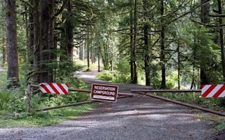
Situated a short distance from the banks of the Stillaguamish River and in close proximity to several wilderness areas, Tulalip Group Campground offers visitors the opportunity to experience both the serene and wild aspects of the Cascade region in Mt. Baker-Snoqualmie National Forest.Surrounded by stands of diverse forest and located in an open, flat area along the scenic Mountain Loop Road, this site is ideal for small group camping excursions.
Recreation
In addition to being a prime location for hiking, fishing, picnicking, and horseback riding in summer and early fall, visitors can take advantage of skiing and snowshoeing in the winter months.Anglers will enjoy fishing from the gently-flowing Stillaguamish River or neighboring Old Mill Pond. The Stillaguamish sustains a large salmon and trout population including chinook, coho, chum, pink, and sockeye salmon, steelhead trout, sea-run cutthroat and bull trout.
Fishing is best in the summer months, though crisp, autumn evenings provide a delightful backdrop for those looking to cast a line in greater solitude.
Facilities
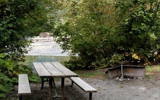
There is only one site at the campground, making it a perfect setting for groups and family gatherings.The site is equipped with tables and campfire rings with grills. Vault toilets are available, but there is no drinking water. Visitors must bring their own water.
River access is available via a short trail from the campground.
Natural Features
The Mt. Baker-Snoqualmie National Forest offers visitors the chance to explore the region's rugged peaks, scenic rivers, and exciting wildlife in the forest and surrounding designated wilderness areas.On banks of the Stillaguamish River, visitors can explore portions of the unique ecosystems typical of the area. Old-growth forests of cedar, fir, and hemlock line the wide, gently-flowing river and tower over trails of underbrush and spring flowers.
On a clear day visitors will see Mt. Baker, the most prominent feature of the Mt. Baker Wilderness Area. Rising to an elevation of 10,781 feet, the active volcano from which the forest takes its name is perpetually snow-capped and mantled with an extensive network of creeping glaciers. Mt. Baker's summit, Grant Peak, is actually a 1,300-foot-deep mound of ice, which hides a massive volcanic crater.
Undeveloped wilderness, clean streams and diverse forests provide important habitat for wildlife to thrive in this region, including lynx, moose, wolves and wolverine.
Nearby Attractions
Visit or stay in one of the historic lookouts in the area. Lookouts are tangible symbols of Forest Service heritage, perched on high peaks with unobstructed views, where they have been used throughout the years to detect and control fires in remote wildlands.Take some time to visit North Cascades National Park or Mt. Rainer National Park to learn about the diverse landscape and history of the area through interpretive programs and exhibits.
Traverse at least a portion of the spectacular Pacific Crest Trail (PCT), one of the world's premier National Scenic Trails. This trail showcases some of North America's most fantastic scenery, winding its way its way from Mexico to Canada through California, Oregon and Washington.
Tulalip Group Camp Reviews
Have you stayed here? Be the first to leave a review!
Top Spots in or near Granite Falls
Dispersed Camp near Beaver Creek Group Camp, Mt. Baker Snoqualmie NF
Granite Falls, WashingtonThis campsite is located along the Mountain Loop Highway. There are various options for dispersed camping around the area, as well as some you can reserve ahead of time such as the Coal Creek Campground and the Beaver Creek Group Campground. This campsite is located just before Beaver Creek group campground coordinates - 48.084115, -121.536540*NOTICE - If dispersed camping, please remember to ...
Big Four Ice Caves
Granite Falls, Washington
4.3
2.38 mi
/ 289 ft gain
Disclaimer: Hiking into the caves is extremely dangerous as there is potential for the ice to fall. We do not recommend hiking inside of them and if you choose to do so, you're doing it at your own risk.
This is a short hike at just 2.3 miles roundtrip with little elevation change. The hike takes you through the forest to the side of Big Four Mountain where the Big Four Ice Caves are. The offi...
Snowshoe to Coal Lake
Granite Falls, Washington
13 mi
/ 1600 ft gain
https://www.theoutbound.com/wa...Starting out at the Deer Creek gate of Mountain Loop Highway the road is flat and uneventful for the first 2 miles or so, though it does offer some great views of the Big Four as well as a few other peaks and the babbling south fork of the Stillaguamish river. The highway is closed for the winter months and well packed down by frequent foot traffic as well as a ...
North Lake via Independence Lake
Granite Falls, Washington
5.56 mi
/ 2431 ft gain
North Lake is everything you could want in a subalpine lake: emerald green hues, cold, clear water, lots of brook trout and far from cell-phone reception. This backpack is perfect when the weather gets hot and sunny, though it does reside in what is known as “the wettest section of the Cascades,” so be prepared for the rain, especially at the beginning and end of summer.
From the trailhead pa...
Cutthroat Lakes via Walt Bailey Trail
Granite Falls, Washington
4.0
6.21 mi
/ 1978 ft gain
Along the Mountain Loop Highway, past the crowds crawling over Mt. Pilchuck, lies the muddy, unkempt Walt Bailey Trail into a verdant subalpine basin speckled with tiny tarns. The Cutthroat Lakes are a delightful location to spend the night with optional day hikes up to exposed ridgelines and craggy peaks.
While the trail’s pitch is rarely too strenuous, the mucky, rocky, rooty bootpath requir...
Hike to Perry Creek Falls & Mount Forgotten Meadows
Granite Falls, Washington
11.5 mi
/ 3700 ft gain
Most visitors park at this trailhead to hike Dickerman Mountain. Until this spring, so did I. However, don't overlook this stunning valley hike to Perry Creek, Mount Forgotten Meadows, and the scramble up Mount Forgotten!Begin this hike on the Perry Creek trail, which begins on the far left side of the parking lot. The trail winds 1.3 miles through a mossy old growth forest and along an old ...
Camping and Lodging in Granite Falls
Granite Falls, Washington
Coal Creek Group Camp
Overview
Coal Creek Group Campground sits along the scenic Mountain Loop Road in the Mt. Baker-Snoqualmie National Forest.Surrounded by s...
Granite Falls, Washington
Red Bridge Campground
Overview
Red Bridge Campground is located just off the Mountain Loop Highway along the pebble-strewn bank of the South Fork Stillaguamish...
Granite Falls, Washington
Boardman Group Camp
Overview
Boardman Group Campground is located about 8 miles east of the Verlot Public Service Center along scenic Mountain Loop Scenic By...
Granite Falls, Washington
Esswine Group Camp
Overview
Esswine Group Campground is located on the banks of the tranquil Stillaguamish River in The Mt. Baker-Snoqualmie National Forest...
Mountain Loop Highway
Marten Creek Group Camp
Overview
Visitors traversing the scenic Mountain Loop Road through Mt. Baker-Snoqualmie National Forest will find Marten Creek Group Camp...
Mountain Loop Highway
Beaver Creek Group Camp
Overview
Beaver Creek campground is a popular group camp situated along the Stillaguamish River, with a spectacular view of Big Four Moun...
Unfortunately, we don't have up-to date pricing data for this listing, but you can check pricing through Recreation Gov.
Book NowAdd your business today to reach The Outbound's audience of adventurous travelers.
Community
© 2024 The Outbound Collective - Terms of Use - Privacy Policy


