
Hiking in Cocora Valley - Home to the Tallest Palm Trees in the World
Come for the wax palms, but stay for the amazing jungle landscape and exciting adventures.
BASIC DETAILS
| LENGTH: around 12 kilometers total (about 7 or so miles)
| TIME: 5-8 hours depending on your speed, fitness and whether you want to take lots of photos (like we did)
| DIFFICULTY: moderate. There are some steeper sections but it is never extremely challenging.
Interesting Things to Know About the Cocora Valley
The Cocora Valley is located on the upper reaches of the Quindio River within the department of Quindio. The valley is part of the larger Los Nevados National Park, a large park that encompasses impressive volcanoes, mountains and many endemic and endangered animals. The valley itself sits at an altitude between 1800 and 2400 meters (5900 - 7870 feet).
The name Cocora Valley actually comes from a Quimbayan princess who was the daughter of the local chief Acaime and means "star of water" (estrella de agua). The Cocora Valley was put aside for conservation in 1985 in hopes of curbing the exploitation of the endemic wax palm, as well as the threats against the species that were dependent on the palm.
Before being put aside for conservation, the biggest threats to the wax palms were the felling of the trees for candle wax, the plucking of the fronds from juveniles for Palm Sunday festivities, overharvesting, disease, and habitat loss.

Getting to Cocora Valley
Cocora Valley is located 11 kilometers from the town of Salento and takes about 20 minutes (by car) to reach. The best way to get there is by taking a Willy (the colorful, WWII-era jeeps) up to the trailhead.
You can find the Willy jeeps in the main square in Salento. The jeeps will be parked near a small white building - which is where you will pay for the tickets (see below).
While the Willy’s can hold around 6-8 people, the drivers are usually fine adding a couple more people onto the back. So if you are feeling adventurous, we definitely recommend riding on the back of the jeep. For it is not only super fun (we loved it so much the first time we did it on the way back as well), but it also gives you great views of the ride up to the trailhead - including views of the surrounding mountains, waterfalls, fincas and the Quindio River.

The Willy’s will drop you off at a small parking lot near all the restaurants and shops that line the street near the entrance to the trail and valley. Since the trail is a loop, once the jeeps drop you off you have to decide whether to head to the left (clockwise) or to the right (counterclockwise). Which brings us to our next point.
DETAILS
| COST: it costs 4000 COP per person, per way to take the Willys. They do ask for total payment upfront so it really costs 8000 COP per person (for the ride there and back).
| TIME: the first Willy departs the square at 7 AM, and then again every two hours until 5 PM. Though we suspect that is just a “possible” schedule and instead they will just run constantly if there is enough demand. The last Willy leaves Cocora Valley at 6 PM.
| WHERE: the main square in Salento, on the opposite side of the church. The exact location is here.
| FUEL UP: if you are looking to grab some food and coffee before heading out on the hike, we suggest stopping by either Café Jesus Martin, which opens at 7 AM and is located right off the square; Café Quindio, which opens at 8 AM and is right on the far corner of the square and Café de La Esquina, a local family-run café that opens at 7 AM and is on the corner of Calle 5 and Calle Real (near the church).

Choosing Your Direction
Because the trail is just one big loop, you do have the option to choose whether to go clockwise or counterclockwise. While many blogs and websites we read beforehand said you should start in a counterclockwise manner, we instead believe going clockwise is the way to go. Here is why:
- You get to see all of the wax palms right at the beginning. While many reports made this the main reason to go counterclockwise (save the best view for last) we instead feel like it is smarter to see the palms first because there is often a high chance of fog rolling in later in the day - aka, you won’t be able to see the giant trees fully. We went clockwise and we were so glad we did because by the time we made it back to the entrance area the whole valley was socked in with a thick fog and we could barely see the wax palms.
- You don’t have to hike up the muddy mountain. Another great reason we think clockwise is better is because you get to hike down the steep mountain that is often very muddy. The trail down twists and turns through the jungle, and while hiking down in mud isn’t super fun (luckily neither of us fell) it is much better than having to climb up. On the day we did the hike, the mountainside was so muddy that you likely would have had to crawl up.
- The elevation gain is very manageable. Similarly, the amount of elevation you do gain is done along a wide trail/road instead of on a single track trail. Plus, the climb is done over multiple kilometers instead of just the one kilometer up the mountain.
In the end, whatever direction you choose to go, you will see the same sites - so you cannot really go wrong. It just all matters on what you want to see first, and how you want to get the elevation gain in (gradual and slow, or steep and fast).
Finding the Trailheads
Once you know which way you want to go, it is time to actually reach the trailhead. Luckily, both are pretty obvious and shouldn’t be too difficult to reach.
| CLOCKWISE: to reach this entrance you simply head up the dirt road from where the jeeps drop you off, past the restaurants and buildings until you reach another busy area with a couple of shops and a big COCORA sign. From here you will see a small building where you will need to pay the entrance fee (5000 COP per person). There is also a map on the side of the building with a basic outline of the loop.

Once you pay the fee, head towards the left. You will eventually get to a wide, two-track road. This is the start of the loop, from here it slowly starts to meander uphill through the famous wax palms.
| COUNTERCLOCKWISE: to reach this entrance you simply cross the road and head down the less busy, dirt road (first passing through some blue gates). Along the way, you will also pass a couple of restaurants, including one serving trucha (trout) from a nearby lake. From there, keep heading straight. Eventually, you will reach a small building where you will pay the 5000 COP entrance fee.
GOOD TO KNOW: if doing the full loop, you will (likely) have to pay the entrance fee twice (5000 COP). So in total, it costs 10000 COP per person (~ $2.60).
The Actual Hiking Route
The loop is around 12 kilometers long and should take you between 5-8 hours depending on your speed and the number of stops you take (either to catch your breath, take in the sites or to just take some photos).
This is a brief outline of the route if you choose to go CLOCKWISE (for counterclockwise, just reverse it).
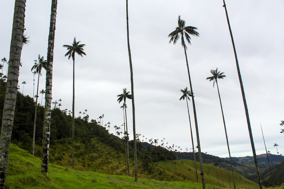
FIRST STOP: THE WAX PALMS
The first part of the hike is through the famous wax palms. This is where you will get the best views of the towering giants and start to understand why the area is so popular with tourists and locals alike.
The trees are just magnificent and in a way, they just seem a bit unreal, cartoonish even. Like Dr. Seuss came in and was told to draw a palm tree.

And because you are seeing them during the beginning of the hike (instead of towards the end) you are more likely to see them in the sunlight and not in fog (no promises though).
GOOD TO KNOW: if you don’t feel like doing the whole loop, you can totally start out on the trail and then turn around either here or at one of the miradors - the first of which is only another 1.7 kilometers up the trail.
SECOND STOP: MIRADOR #1
Once you pass through the forest of wax palms you will start the gradual climb up into the mountains. The first mirador is pretty basic, but it will give you some good views of the palms as well as the surrounding mountains.
THIRD STOP: MIRADOR #2
The second mirador, located just over half a kilometer from the first, has better views of the palms as well as a nice close-up view of the surrounding mountains, including the most prominent mountain of the hike: El Pino.

FOURTH STOP: FINCA LA MONTANA
Once you leave the second mirador the landscape begins to change. You have now left the wax palms behind and instead start to enter the thick forest. In the beginning, it is more pine forest-y (make sure to look for colorful birds) before it starts to become more jungle-like.
During this part of the loop, the trail is still a rather wide dirt road and it is still climbing gradually. Eventually, you will reach a small building and gate where some park rangers are stationed. The rangers were very friendly and actually spoke super good English. They told us that the river was very high and that if we didn’t want to cross it we could turn around and come back this way. While they didn’t ask for an entrance fee, they did tell us that we would have to pay another 5000 farther down the trail (which we did). If you are going counterclockwise, this might be where they ask for the second entrance fee.
Within another kilometer or so you will come to a single track trail that shoots off into the forest on the left. This trail leads deeper into Los Nevados National Park, but unless that is your goal (which is a great goal) you will instead stay on the main trail. Keep going for another kilometer until you reach another mirador and Finca La Montana.
GOOD TO KNOW: Finca La Montana is actually private property, so we do not believe it serves up any sort of drinks or treats (at least it didn’t when we hiked the loop). But, the viewpoint next to it is very nice. Plus, this is around the halfway point - and the last of the uphill section - so it is a great spot to take a nice break.

FIFTH STOP: ACAIME RESERVA DE COLIBRI
This is actually a detour from the main trail, but if you have the time and the desire to see some colibries (hummingbirds) we highly recommend the stop. Plus, you not only get to see some hummingbirds but you also get a nice refreshing drink (it is included in the entrance fee).
Sadly, it was closed when we visited in August (2021) but we suspect it would be open later in the season (maybe when the river calmed down…).
DETAILS
| COST: it costs 6000 COP per person, but also includes a drink
SIXTH STOP: THE BRIDGES
By the time you reach the turn off for the hummingbird sanctuary you have already conquered the steep (likely muddy) downhill section and have fully entered the jungle. This is also when you will get a nice close-up view of the powerful Quindio River, which snakes through the forest before heading out towards Salento.

If you are doing this hike when the river is high (like we did) you will notice that the trail is completely covered by the raging river. While you can still hike along the edge and get your legs mostly soaked - this is what Madalyne did - we suggest instead making a quick detour up and over to where the trail recommences on higher ground (this is what Luke did).
Keep heading down the single track (but wide) trail, through the thick jungle until you reach your first bridge. Now, while it might look totally unstable and completely terrifying, the narrow wooden bridges are actually quite fun. Yes, there are pieces of wood missing, yes they swing back and forth, and yes the river underneath is quite powerful. But. It is all part of the adventure right?
By the time you finish this section of the trail, aka the “Jungle Section” you will cross six wooden bridges - and all of them will be a bit nerve-wracking (but oh so photogenic :).

SEVENTH STOP: CASCADA BOSQUE DE NUEBLA
This is another (super quick) detour from the main trail (don’t worry it only takes about a minute) but totally worth it. Once you pass the last of the bridges you will see a somewhat hidden sign on the right side of the trail pointing towards a waterfall.
Take the slightly slick trail down to one of the prettiest waterfalls in the area: Cascada Bosque de Nuebla (Fog Forest Waterfall).
Once you get your fill of the falls, head back up to the main trail and continue down the trail. Soon you will reach an opening and another big sign, which reads FUNDACION HERENCIA VERDE. This is the beginning of the private property as well as the start of the open meadows and the end of the jungle section.
EIGHTH STOP: THE FARMLAND
As we said, this is private property so much of the trail will be lined with a fence. The trail here is also separated into two sections: one for uphill traffic and the other for downhill traffic. Though if it isn’t busy, your best bet is to take whichever trail is less muddy.

The farmland is very lush and pretty in its own way. You will likely see some cows and horses and maybe a few birds. Plus, you will be able to see some of the giant palms once again. By now the trail is mostly flat to downhill and very easy going.
When we did the loop, by the time we reached the farmland area of the hike the fog (nuebla) had officially rolled in. The whole area had a slightly eerie feel to it, especially when a sudden bird would cackle from one of the nearby trees. While we enjoyed the sudden change in weather - we were a bit sad to no longer be able to make out the giant palms.
From the start of the farmland section, it is about another 5.5-6 kilometers to the end of the loop.
GOOD TO KNOW: if you are starting to get a bit hungry by now (we definitely were), then look out for a small food cart selling ice cream and empanadas about halfway back to the road.
This hiking loop is a great way to fully immerse yourself in the nature and landscape of what makes the Cocora Valley so special. Not only do you get amazing up close views of the wax palms, but you also get to explore and adventure in the beautiful vibrant jungle.
If you are looking for a fun, active day out in nature then we highly recommend doing the entire Cocora Valley loop. We promise you won’t regret it!

What to Bring
Here is a quick breakdown of what you should bring on your hike around the Cocora Valley. Again, we want to say that there are almost no services along the loop hike (unless you stop by the hummingbird sanctuary).
- Sturdy shoes. Hiking boots would be best but you can really do it in any shoes that have good support and grip (Madalyne hiked the loop in running shoes).
- Rain jacket. The weather can change pretty quickly - from sunny to foggy in the span of 30 minutes - so definitely pack accordingly. A light rain jacket is a great extra layer to bring with you just in case the weather does turn.
- Sun hat. This is especially needed for the first part of the hike around the actual palm trees, for there is not a lot of sun protection.
- Sunscreen & bug spray. Similarly, bring some sunscreen and use it - especially if you are planning to be out in the sun taking photos for a while (or just hanging out and relaxing in the sun). The hike starts at 1800 meters (5900 feet), so the sun is very strong. Also, bring some bug spray because during the jungle section of the loop there are a good number of mosquitos.
- Water & a water filter. This should be a no brainer, but make sure to bring plenty of water with you on the hike. A good rule of thumb is to bring 1 liter of water for every 3 hours of hiking you are planning to do (more if the trail is going to be very steep or hot out). If you don’t want to carry all of that water with you, then definitely bring a good water filter for there is plenty of water along the trail.
- Snacks. Another thing that should always be in your hiking bag are some good snacks. You can easily pick up some simple snacks at the small mercados in Salento or at one of the local cafes. Or if you are really desperate, you can always grab a couple of quick snacks at one of the stalls at the trailhead.
- Extra: a camera! The wax palms are incredible and very unique so if you have a camera (even just your phone) definitely bring it with you.
INSIDER INFO: also make sure to snap a photo of the map at the entrance and/or download the Salento and Cocora Valley section on maps.me. This will give you peace of mind knowing you are still on the right trail when out hiking.

We want to acknowledge and thank the past, present, and future generations of all Native Nations and Indigenous Peoples whose ancestral lands we travel, explore, and play on. Always practice Leave No Trace ethics on your adventures and follow local regulations. Please explore responsibly!
Do you love the outdoors?
Yep, us too. That's why we send you the best local adventures, stories, and expert advice, right to your inbox.


