
Backpack to the Beartooths
Roscoe, Montana
Details
Distance
14 miles
Elevation Gain
7620 ft
Route Type
Out-and-Back
Description
Added by Seth Langbauer
Challenging 7-mile trek up to the base camp at Glacier Lake below the Beartooths (14-miles roundtrip). View both Metcaf and Spirit Peaks from camp. Beware of the "No-Fall" zones in the boulder fields on the trek to camp. Total elevation gain of 7,620 feet. Duration: A few days.
We stood there, against the wind, looking at 3-4 pitches. The line appeared too good to be true. It was a bit of an ice pitch, followed by a snow coliour, finishing with a pitch of mixed climbing that would take us to the top.
I'd heard things about The Beartooths. But, they weren’t validated until I was there. I had previously envisioned some sort of Yosemite meets the Wild West.
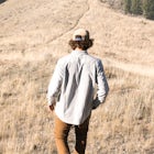
Aki and I drove from Bozeman and met Justin behind a Conoco in the nearest town. We loaded skis, packs, tools, and food into my truck and set out towards The Beartooths. Conditions allowed us to drive all the way to the trailhead, with just enough slipping and sliding to keep the drive exciting. According to Justin, this was a rare commodity in The Beartooths. At the parking lot we made a difficult choice: to ditch the skis. If we were wrong, and there was plenty of snow to ski on, we'd be post holing for 5 miles. If we brought them and there wasn't snow, we’d be carrying dead weight. A mile up Rock Creek moral was high, until we reached the first boulder field. There were endless boulders the size of VW Bugs covered in snow. Justin, who has been in mountaineering boots more than street shoes nimbly jumped between rocks as Aki and I started to question our abilities. I distinctly remember two "no fall zones". No fall zones in a boulder field were a new concept to me. Up the first pass, we descended towards our goal of Glacier Lake.
We arrived in the wind. Planning on climbing the next day we set up the tent before it became too cloudy and we lost our chance at scouting a line. Tent stakes were worthless. Ski poles and ice axes barely held down the tent in the wind. Weary we hiked up the lake and spotted it. We snapped some shots of the line and headed back to the tent hoping it hadn’t blown away.
That night was the strongest wind I have ever experienced. The previous year I had been on a ski trip in the Crazy Mountains with Aki. Gusts of wind came down the valley that sounded like trains. This was worse. We continually woke up as the walls of the tent were blown into our faces.
3am came. Justin started to sort through gear. A full rack of nuts. Ice screws. Pitons. We divided gear and unzipped the tent. Fortunately there was a full moon; unfortunately there was 8 inches of new snow. Our ice tools were buried. Once we had dug up everything we did the best we could to secure the tent. Secured by just ski poles it was a serious possibility that the tent wouldn’t be there when we came back.
We didn’t make it to the climb. Crossing another boulder field in the dark was a tenuous effort, but what lay after it was what made us turn around. After the boulder field, we came across a series of snowfields. We could cross them to avoid more rock hopping. Aki and I were weary of avalanche conditions with the new snow, but it wasn’t on Justin’s radar. On the second to the last snowfield I experience my first “whoomf”. The Three of us froze in the middle of a thirty-foot snowfield. We calmed down to assess the situation and decided to backtrack to a rock rib. From a safe point we decided to turn back to the tent. The fourth field was bigger and steeper. Without beacons and rescue equipment it would be irresponsible to attempt to get to the climb. We now faced a terrible traverse back to camp. Deciding it would be safer to traverse the boulders the entire way instead of using snowfields, we reached our camp hours later. The tent was there, but buried under new snow. We dug up the tent, Justin snapping a ski pole in the process, packed up our bags and started the trudge back to the car. We post holed for hours. We reached the truck with soaked socks and frozen boots.
It was an introduction to alpine climbing I won’t forget. It was also a display of Montana’s mountains, weather, and playground. The Beartooths have a lot to offer. It’s been long enough now, that I can start to think about returning.
Download the Outbound mobile app
Find adventures and camping on the go, share photos, use GPX tracks, and download maps for offline use.
Get the appFeatures
Backpack to the Beartooths Reviews
Wow! What an adventure to hike the East Rosebud trail during the winter. Looks like a true test of survival. We were able to hike it earlier this year in June, and understand where it gets the nickname "The Beaten Path" (at least during the summer months). The trail was heavily populated, for good reason though. Its a very scenic hike that can ultimately take you 25 miles to Cooke City. From the looks of it though, you guys didn't have any problem with coming across people.
5.0
Leave No Trace
Always practice Leave No Trace ethics on your adventures and follow local regulations. Please explore responsibly!
Nearby

Backpack Granite Peak

Backpack to Rainbow Lake via the East Rosebud Trail

Backpack the Beartooths via the West Rosebud Trail

Snowshoeing to Silver Falls

Mountain Bike Willow Creek Trail no. 10

Backpack the Aero Lakes to Granite Peak
Community
Mobile Apps

© 2024 The Outbound Collective - Terms of Use - Privacy Policy