Outbound Collective logo

Cone Peak in Big Sur (Sea to Sky Backpacking Route)

Big Sur, California

4.5/5
based on 15 reviews

Details

Distance

19.72 miles

Elevation Gain

7484 ft

Route Type

Out-and-Back

Description

Added by Josiah Roe

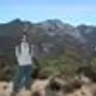
Cone Peak is the most spectacular coastal mountain in the Lower 48 States. At 5,155' high and less than 3 miles from the ocean, the average gradient from summit to sea is 33%, which is steeper than Mt. Whitney to Owens Valley.

While you can make a day-hike out of it by driving up the gorgeous Sur-Nacimiento Road from Highway 1 to the Coast Ridge Road and take a 2 mile trail to the summit with 1300' of elevation gain (4 miles roundtrip), the more adventurous types do a Sea to Sky, starting at Kirk Creek Campground and up Vicente Flat Trail (23 miles roundtrip). You can camp at Vicente Flat 5 miles in. Another 2.5 miles up and you'll connect with the Coast Ridge Road, take a left and then up the Cone Peak trail to the summit.

You can camp on the summit if you like, near the old fire lookout. Unless you're during the week or in winter, don't expect to be alone for the hike.

For current fire closures and conditions, check http://calfireinformation.weeb... and http://calfire.ca.gov/. Illegally entering the area during closures can result in large fines.

Read More

Download the Outbound mobile app

Find adventures and camping on the go, share photos, use GPX tracks, and download maps for offline use.

Get the app
Download GPX File

Features

Camping
Backpacking
Hiking
Bathrooms
Beach
Easy Parking
Forest
Picnic Area
River
Romantic
Scenic
Waterfall
Wildflowers
Wildlife

Cone Peak in Big Sur (Sea to Sky Backpacking Route) Reviews

I did this as a 3-day out and back, spending both nights at Vicente Flats. The view on the first day is great, but it’s nothing compared to the views on the way up from Vicente to Cone on the second day. I was glad I had a day pack to get me up and down to Cone peak because the ascent was rough, especially the final 1/4 mile. Very enjoyable all around

i did this as my first solo trip and it couldn’t have been better. the trail was nearly empty so i got to have my solitude, but the campsites were always busy so i felt no fear being alone. views, people, and the wildflowers were all so beautiful, will definitely do this again one day:)

We backpacked the "lollipop" loop over memorial day weekend, in three days. This hike definitely was not easy, as the first two days were mostly uphill and it rained on us the second day. There was poison oak everywhere!!! If you are severely allergic, you may not want to do this hike. Usually it was sticking out onto the trail from one side, but there were a few times where it was sticking out onto the trail from both sides, making it inevitable to not touch!! We used Tecnu every night on our hands and arms. Please check out my video of this trip on Youtube "Backpacking Hwy 1 to Cone Peak by Big Sur" by Kiki's Adventures if you would like to see what the trail is like! Day 1: Parked across from Kirk Creek Campground and hiked through Vicinte Flat Campground and up to Goat Camp for the night (~12 miles). There was plenty of water at Vicinte Flat Campground when we were there and there was also a waterfall right before you get to Goat Camp. Day 2: We hiked from Goat Camp up to Cone Peak and back down to Vicinte Flat Campground for the night (~10 miles). Day 3: We hiked from Vivinte Flat Campground back down to Hwy 1 where we parked our car across from Kirk Creek Campground.

It is dismaying to see so many posts that glorify camping at the summit of Cone Peak. Such behavior is completely inappropriate. Over use and under management of the public lands of the Big Sur backcountry is resulting in tremendous resource damage cause by uninformed visitors. The only appropriate places to camp in the Ventana Wilderness are at ESTABLISHED CAMPS where human impacts have been long-established. The dramatic increase in summit camping and the proliferation of new campsites throughout the Ventana, fueled by social media such as this site, is resulting in the dramatic degradation of this protected Wilderness and many others across the west. One might think, "I see no impacts. I'm just one visitor. I pack out what I pack in." The reality is that your impacts are akin to "death by a thousand cuts." Once impacts begin, we humans are adept at taking them to the next level ... and the next ... until we eventually bemoan the damage done. Please people, go to Cone Peak. Enjoy it its wildness ... its specialness. But do not camp there and for heavens sake do not ever have a fire there!!!!! Please use nearby established camps such as Vicente Flat, Trail Spring, Goat, and Ojito. These camps usually have water and are already impacted by us. I tis up to us to keep it wild. Realizing that all of us have an impact on fragile wild places is the first step in enjoying the great outdoors responsibly.

For clarification, the hike route described here, climbing Cone Peak via Vicente Flat Camp, while scenic, strenuous, and enjoyable is not what locals consider the "Sea-to-Sky Route", which instead climbs Cone Peak more directly, along Stone Ridge via usetrails. A link to an interactive map of the Sea-to-Sky route (from the same website as the original poster used for his "Map" link) is at: http://bigsurtrailmap.net/ROUTES/SEA-TO-SKY/sea-to-sky_route.html (which can be panned to show other Cone Peak trails, notably the ones described in the original post). The true "Sea-to-Sky route" is intended for extremely strenuous out-and-back day hikes, not suitable for a backpack. So backpackers wishing a "sea to sky experience" should take the route described here - after first using the trail at Kirk Creek Campground to put their finger/toe into the ocean to make it complete.

Beautiful trail and location. Fill up with water at Vicente flat. We made camp there and then hiked the rest of the way without heavy packs. We had a close encounter with an aggressive mountain lion just north of Vicente. Make sure to bring food bags for overnight and make loud noises / brief yourself on what to do if you run into an animal such as this.

Leave No Trace

Always practice Leave No Trace ethics on your adventures and follow local regulations. Please explore responsibly!

Nearby

Hike from Kirk Creek Campground to Vicente Flat Trail

Clifftop Camping & Hot Springs in Big Sur

Surf Willow Creek

Camping at Limekiln State Park

3 Branches of the Limekiln

Goat Camp via Twitchwell Flat Use Trail