
11 Awesome day hikes along the Appalachian Trail

The Appalachian trail is approximately 2,180 miles of public footpath from Georgia to Maine that traverses 14 states along the Appalachian Mountain Range in the Eastern U.S. Backpacking the entire trail could take 5-7 months, depending on factors like speed and experience.
Completing an Appalachian Trail thru-hike is a life-changing feat, but realistically, it’s not for everyone. Luckily, there are many ways to enjoy and feel the magic of the AT without committing to months of living out of a backpack.
There’s no shortage of opportunities to appreciate the crests, valleys, and views of this undeniably gorgeous mountain range, even if just for a day. And if you happen to be curious about thru-hiking and want a little preview, you may bump into people along the way who are willing to stop and share some stories! Check out these day hikes along the AT for a shorter, less time-consuming experience.
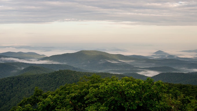
1. Blood Mountain – Georgia
Distance: 4.34 miles
Elevation gain: 1447 ft
Type: Out-and-back
Blood Mountain is the highest peak on the Appalachian Trail at ~4,458 ft and is located in the heart of the Chattahoochee National Forest. At the top, you can soak in the splendid Blue Ridge Mountains. During this hike, you’ll traverse through creeks, hills, big rock formations, and dense woods. It’s safe to say that the views on this adventure do not disappoint. There are a few false summits on your way to the top, so keep pushing onward! You’ll know you have reached the end when you see a stone cabin built by The Civilian Conservation Corps in 1934. Take time at the summit to kick back, marvel at the view, enjoy a picnic, or stay for the sunset for a stellar photo opportunity (so long as you have a headlamp to get back down). The Mountain Crossings hostel and gear shop is located nearby, where you can stop in for an ice cream, pizza, or choose from a full pantry of food. Alternatively, check out one of the nearby wineries, like Wolf Mountain Vineyards for a post-hike wine tasting.
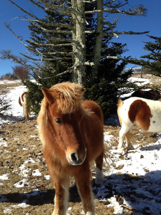
2. Grayson Highlands – Virginia
Distance: 9.1 miles
Elevation gain: 1549 ft
Type: Out-and-back
Many years ago, ponies were introduced to Grayson Highlands State Park, a portion of Jefferson National Forest. To this day, they freely graze the grasslands. What could be more exciting than spending the day admiring beautiful Blue Ridge Mountain and meadow scenery with a chance to spot a wild pony? A majority of the ponies are near Rhododendron Gap towards Mount Rogers. Though many of these animals are known to be friendly, remember they are still wild animals, and you should give them space. The Grayson Highlands General Store & Inn is a nice place to stop for a post-hike beer, snack, or sandwich.
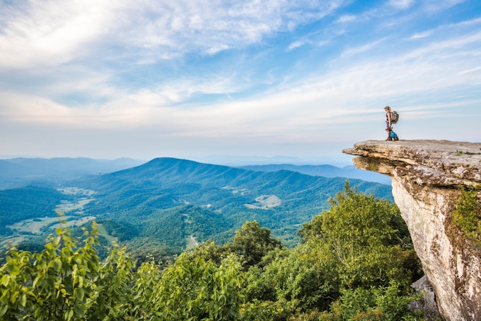
3. McAfee Knob - Virginia
Distance: 7.79 miles
Elevation gain: 1296 ft
Type: Out-and-back
This three-ish hour hike includes 270-degree views of the Blue Ridge Mountains. The clearly-marked trail is popular, so many people start early in the morning and reach the summit before noon. If you end up out late, consider taking the fire road back down to reduce your route by 1/2 mile and increase visibility for your nighttime hike.
Note: the only water source on this hike is a spring at Catawba Mountain Shelter, which you'll pass on the trail. When you return to the trailhead at the end of your Appalachian Trail adventure, head to Abrakebabra for delicious gyros and falafel!
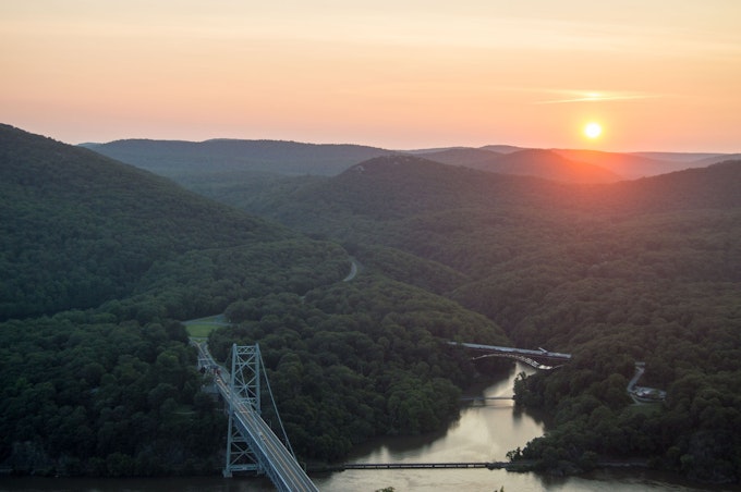
4. Anthony’s Nose – New York
Distance: 1.95 miles
Elevation gain: 682 ft
Type: Out-and-back
The hike to Anthony’s Nose is an iconic spot to check out sweeping Hudson River Valley views. You’ll know you made it to the top when you spot an American flag waving in the wind. Enjoy a snack on the rocks at the summit while looking out at Storm King Mountain and Bear Mountain Bridge. Still hungry after your return to the trailhead? The nearby town of Highland Falls has a selection of cute restaurants, cafes, and bars like the Bear Mountain Bakery & Cafe. We recommend the bourbon pecan pie.
5. Race Brook Falls – Massachusetts
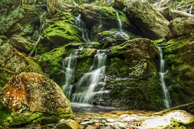
Distance: 3.4 miles
Elevation gain: 1174 ft
Type: Out-and-back
This hike has the feel of a tropical jungle adventure, even though it's on the East Coast! In addition to the impressive 100-foot falls, you’ll marvel at large hemlock trees, thick pine forests, and cascading streams. The waterfall mist creates an environment conducive to lush greenery growth in the warmer months. In the winter, the area transforms into an icy wonderland! Be especially cautious, as the rocks are slippery, and the falls are powerful!
6. Mount Katahdin – Maine
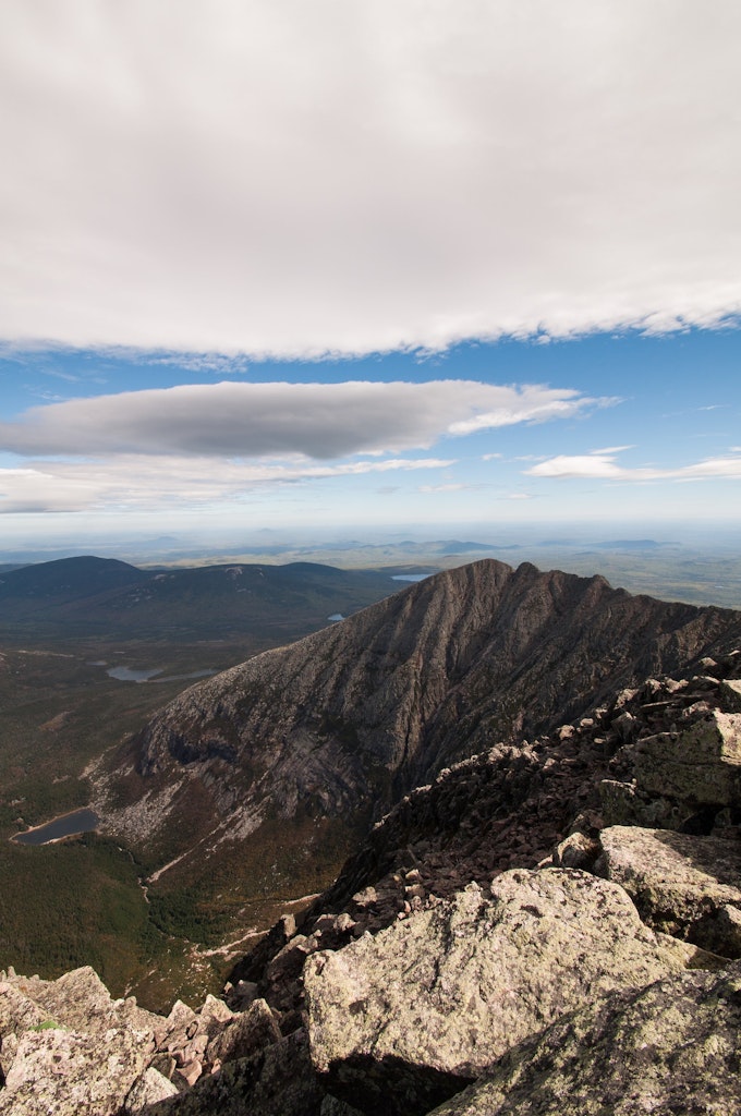
Distance: 10.4 miles
Elevation gain: 5000 ft
Type: Out-and-back
Mount Katahdin is the highest peak in Maine, at about 5,268 feet. It was named by the local Penobscot Native Americans meaning “The Greatest Mountain,” in Algonquin. This adventure is an especially magical day hike as it marks the northern terminus of the AT, located in Baxter State Park. You may bump into thru-hikers finishing up their long quest, making it potentially one of the most emotional and inspiring day hikes you can imagine.
Much of this hike is above treeline, so be prepared for all the elements. Aside from the weather, the route treks through large rocks, roots, and mud – not ideal for the beginner hiker. Before setting off, Baxter State Park requires hikers to obtain an AT Hiker Permit card at the Katahdin Stream Ranger Station. Since it's a more popular hike, making reservations ahead of your visit is a good idea.
Be aware of trail closures due to inclement weather, and note that trails to Katahdin typically close in October and don’t reopen until late May-June. After your hike, celebrate your efforts by grabbing a meal and baked goods at the Katahdin General Store or commemorate your experience with a Katahdin hat or sweatshirt.
7. Lehigh Gap – Pennsylvania
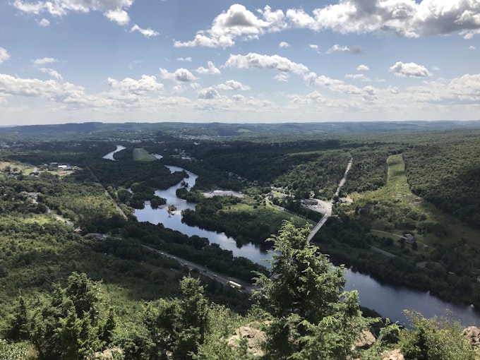
Distance: 2.5 miles
Elevation gain: 730 ft
Type: Loop
This adventure leads to gorgeous views of Lehigh Gap from rock piles at the summit. Lehigh Gap formed when the Lehigh River carved a hole into the foothills of the Appalachian Mountains. During your ascent, you’ll need to scramble up a few rocks, but the trail returns to dirt and grass soon after. Eventually, you’ll get a clear view of the bridge and the surrounding valley. Check out the Lehigh Gap Nature Center, a non-profit conservation organization at the base of the Kittatinny Ridge. Browse their schedule to see if you are interested in attending one of the upcoming educational events.
8. Franconia Ridge Loop – New Hampshire
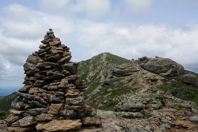
Distance: 8.9 miles
Elevation gain: 3600 ft
Type: Loop/out-and-back
This adventure is teeming with photo opportunities at every turn. Less than a mile into the trek, the trail splits into Old Bridle Path to the left and Falling Waters Trail to the right. You can choose to do an out-and-back trip or a loop. At the end of Old Bridle, Greenleaf Hut houses food, cots, water, and bathrooms if you need to stop and take a break.
Keep going and be prepared for the last half mile of this journey, often referred to as “Agony Ridge,” a rocky scramble to the finish. Take note of the cairns up to the top for guidance. This adventure is exposed and gets steep at several points. It also includes some river crossings, so plan accordingly and wear appropriate layered clothing. Don’t let the challenge deter you from experiencing the awe-inspiring views at the top!
9. Roan Mountain – North Carolina
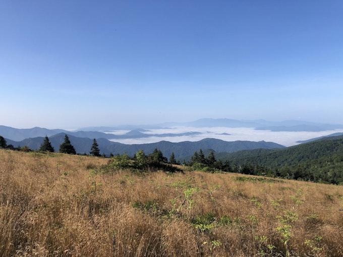
Distance: 6.98 miles
Elevation gain: 1204 ft
Type: Out-and-back
The path from Carvers Gap to Roan Mountain is a less-crowded section of the trail. If peace and solitude are what you’re looking for, this could be the right spot for you! Several balds along the trail are great stopping points to soak in the views. In the summertime, you’ll get to enjoy lush green grasses and blooming rhododendrons while overlooking miles of the vast Blue Ridge Mountains.
10. Laurel Falls – Tennessee
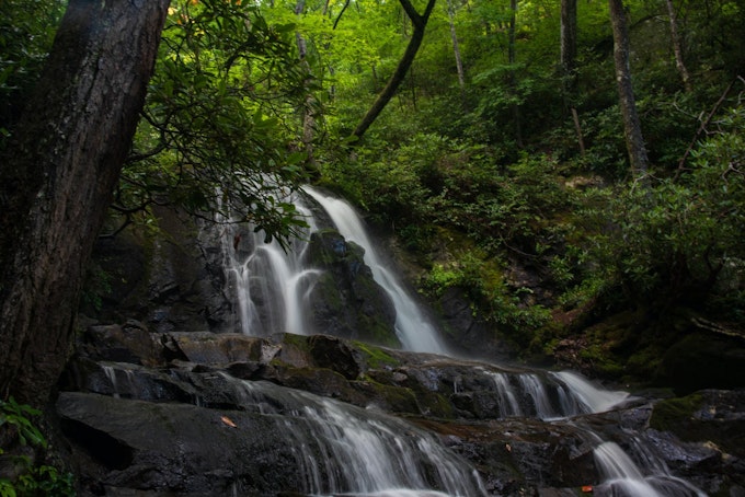
Distance: 2.45 miles
Elevation gain: 314 ft
Type: Out-and-back
Located in Great Smoky Mountains National Park, Laurel Falls is an impressive 80-foot, tiered display of free-flowing water. The trail is paved and easy to follow, making it one of the more popular family-friendly adventures in the park. If you want to avoid crowds, head out early or later in the day to catch sunrise or sunset. Be bear-aware, as there have been black bear sightings in the area. Nearby Elkmont Campground Store is an excellent place for a bathroom break or snack stop!
11. Weverton Cliffs – Maryland
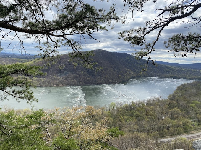
Distance: 3 miles
Elevation gain: 1500 ft
Type: Out-and-back
This adventure features stunning views straight down the Potomac River that also looks back on the Harper’s Ferry area. The beginning of this hike is quite steep and features a few switchbacks. Your efforts will be rewarded at the top, where you can look down at the river and maybe spot people tubing or canoeing in the warmer months. Stop by nearby Harpers Ferry Outfitters Hike & Bike Supplies to browse through Appalachian trail outdoor gear and equipment for all your adventure needs!
Cover Photo: Christin Healey


