
The Y Trail
Provo, Utah
Details
Distance
2.29 miles
Elevation Gain
1063 ft
Route Type
Out-and-Back
Description
Added by Annelise A
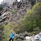
A hike to the top of the iconic Y on the mountain overlooking Provo, Utah.
Hiking the Y is a classic hike in Provo, Utah—but don't expect it to be easy! There's no shade and not much greenery, so it's a hot, dusty trek to the top. Once you reach the Y, though, the view of the Provo and Utah Lake is amazing. There are also benches at the top.
When you reach the Y, you will first come to a point about halfway up the Y. You can stop here or keep going up the fork in the trail to your right up to the top of the Y. You can go out and walk/sit/dance on the Y itself, but be careful as it is very steep.
If you hike at night, you'll avoid the heat! Just be prepared—night or day—for steep switchbacks all the way up. There are bathrooms and parking at the trailhead; if the parking lot is full (this is a popular hike!), you can always park on the side of the road leading up to the parking lot.
Many people also run this trail—definitely a good workout whether you're running or hiking!
Directions:
From 900 East, turn east on 820 North, keep to the left, the street will change to Oakmont Lane, take a right onto Oak Cliff Drive, then a right on Terrace, finally a left into the parking lot.
Coordinates:
- TH 40.2448, -111.627
- Y Mountain 40.2483, -111.621
Download the Outbound mobile app
Find adventures and camping on the go, share photos, use GPX tracks, and download maps for offline use.
Get the appFeatures
The Y Trail Reviews

Going to BYU, I was always invited to hike to the Y, but it's honestly not that fun of a hike. It's fun for nostalgia sake if you're a BYU student or just love the Y, but there are much prettier, comparable trails close by to the Y. The trail is really steep (as it was meant for maintenance vehicles) and is exposed the entire way. Unless you go at 5 Am, you will always be in the hot sun hiking up and I am not a fan of that.
3.0
This is a good hike that doesn't take very long but has a great view as a pay-off at the end. A lot of people are surprised by how steep the switchbacks are and how much effort it really does take, so bring plenty of water. It is frequented by tourists and families so be prepared to share the trial. If you are a people person, it is no problem...if you are looking for alone time in nature, this is not the place to find it.
4.0

Have done this hike since I was a little kid with my family. Do it once a year. Awesome view of the valley
5.0
Leave No Trace
Always practice Leave No Trace ethics on your adventures and follow local regulations. Please explore responsibly!
Nearby

Hike to Buckley's Abandoned Mine

Snowshoe the Rock Canyon Trail

Hike Squaw Peak

Rock Climb in Rock Canyon

Hike to the Summit of Buckley Mountain

Buffalo Peak Trail
Community
Mobile Apps

© 2024 The Outbound Collective - Terms of Use - Privacy Policy