
Zach L
Fairly popular trail, plenty of elevation gain to make the pond at the end. Good views of the city from an overlook about 3/4 of the way up. Felt a bit like bushwhacking toward the end but the pond makes for a great lunch/picnic spot before heading back down.
4.0
I hiked this a few years ago although I believe it is still closed. This trail offers many of the features of classic Zion hikes (chains, narrow canyons, beautiful views, and mild scrambling) while still flying a bit under the radar. If/when it opens back up, early/mid November is a beautiful time to check it out, it'll be decorated in some extra colors.
5.0
Regardless where you start this hike (Stinson, Steep Ravine TH, Whitegate Ranch TH, etc) this is a great trail and an inspiring route through some old growth forest. Would recommend going UP steep ravine and DOWN Dipsea using Old Mine as a connector at the Pantoll Campground. The signage is good and there’s so many different loops from Pantoll that you can add as much additional mileage as you’re up for. There’s also a ranger station that is staffed if you have questions or need recommendations.
5.0
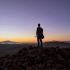
This is a beautiful trail, especially on a clear day where you’ve got views both into the bay and out to the ocean. Even when conditions are foggy you can get lucky and see elk, quail, coyotes, and other wildlife. It’s not all up or all down which is nice but the end is a bit sandy so have a picnic while you rest up for the return trip.
5.0
Agree with the other review, a must-do trail. There's marked plants along the way to brush up on the local flora and then you can just admire the rugged views from the end. I happened to be out there for sunset and it was a great cap to a day exploring Black Canyon.
5.0
We parked our rental in Doolin and took the walking trail from town all the way to the O'Brien Tower then caught a shuttle back to Doolin. We had blue skies and sunshine all day in mid-July but we may have gotten lucky, In my opinion this was a great way to see the cliffs, get some exercise, and work up an appetite for some Irish Stew and a Guinness back at Gun O'Connors when you return to Doolin.
5.0
A friend of mine and his wife recommended renting bikes in Killarney, taking the boat across the lake, and then biking back to Killarney. While we couldn't get the boat shuttle across the lake, I dropped off a bike at the top, parked at Katie's Cottage, hiked up, then biked back down. However you do it, this is a beautiful valley with sheep, stone bridges, and iconic Ireland countryside.
5.0
Visited in July and the weather was rainy and a low fog obscured the top of the mountains before moving down and shrouding most of the views. This was the top of my Ireland bucket list and it was beautiful, I can't wait to return to hike when the skies are clear.
5.0
This is a paved trail along the rim with terrific views down into the eroded amphitheaters. I've visited Sunrise Point for sunrise and Sunset Point for sunset and I don't think you can go wrong with either point at either time of day. If you're not up for the steeper Navajo Trail from Sunset Point I would recommend the Queens Garden Trail, it's more gradual and even going out only part way and gets you down among the spires and offers some great views.
5.0
The time I visited in February, Wall Street was closed so I had to go down/up the same section of the Navajo Trail. Bryce is higher elevation (8k ft) so they get more snow and colder temps than Zion and other areas below the plateau. I didn't need spikes but the switchbacks were full of sloped ice from packed/melting snowfall. I definitely wouldn't recommend it for those who aren't sure-footed. With that said, Bryce is a beautiful destination in the winter!
4.0
Nice hike up and over Smith Rock SP and a great stop even for non-climbers. The beginning is a decent climb which gets your heart rate up but the views of the Crooked River and eventually out toward the Cascades are well worth the effort. I made it a loop and took the Mesa Verde Trail down to the River trail which is a very serene and peaceful riverside walk to bring you back to the bridge.
5.0
To be honest, the dunes were less “pink” than I expected but they were still a fairly vibrant orange/salmon color and this probably changes a bit seasonally, and based on time of day. The sand was very fine and it was fun to ditch the shoes and walk around the dunes barefoot (until it got too hot). It’s a state park and there’s an entrance fee but it’s a good spot for a picnic, there’s even an observation deck (grandstands) where you could sit and watch a sunset dance over the dunes.
4.0
This trail follows a sandy/rocky wash as one entrance into Buckskin Gulch. It is flat, easy, and relatively bland until you get close to the entry into Buckskin. When you reach the first “slot canyon” there’s a dry fall that you’ll have to navigate, in the past there have been rocks/logs for some assistance. It can be a little intimidating for some but it is passable (both ways) and easier than you might think. Wire Pass is not the real attraction, it just happens to be the trail that gets people to The Wave or Buckskin Gulch, the two stars of the show.
4.0
Started at Sunset Point, took the Navajo Loop down through Wall Street and then branched off on the Peekaboo Loop. It’s all down until you begin Peekaboo, then it’s quite a bit of up and down. If you want to spoil the surprise, watch the faces’ of people coming toward you: if they look happy it means they just had a nice downhill stretch which means you’re in for a climb…if they look sad, then you’re about to get a break. Take plenty of water, it’s unlikely you’ll get any until you return to the rim, and watch for the horses (and horse poop). Keep in mind that you’re around 8k feet so there’s some added challenge to this hike, especially once you’re done with the loop but still have to climb out on the Navajo trail. Regardless, anytime you can get down amongst the hoodoos in BCNP is a good hike and this one is no exception.
5.0
A short drive off the main road to a parking area. Neat to see how rugged the landscape is here compared to the smooth salt flats of Badwater only a few miles up the valley. It’s a short stop, there’s no real trails and it’s unlikely you’ll want to venture very far from the parking area due to how difficult it is to walk on.
4.0
Easy trail and a good introduction to the Redwoods. I thought Stout Grove was a bit better but any chance to take a peaceful stroll through these giants is worthwhile. If you’re looking for an even more serene walk with fewer visitors I’d suggest the James Irvine trail out of Prairie Creek, either as an out and back or make a long loop via Miner’s Ridge.
4.0
Great path between Incline and Sand Harbor for dog walking, jogging, and biking. The parking at Tunnel Creek fills up quickly but later in the day there are usually spots opening up. Bike or jog to Sand Harbor, take a swim, and return to Incline for a nice out and back. Other than the initial climb headed out of Incline the trail is fairly flat.
5.0
Very pretty hike through a rugged canyon. It does require navigating some drops and choosing the best path for your abilities. Keep an eye out for cairns and be prepared for some scrambling. Bring plenty of water, wear sunscreen or a sun cover, and maybe take a bathing suit if you’re brave enough to swim in the cool, clear Colorado (the water is cold because it’s coming from the bottom of the Glen Canyon Dam).
5.0
Beautiful and serene walk through the Redwoods, I only encountered a few other people toward the end of my hike. I thought the James Irvine trail was more scenic than Miner’s Ridge so if you’re not doing the loop I’d stay on James Irvine and just do an out and back. Lots of old growth Redwoods and plenty of unbelievably large tree trunks to marvel at. There’s also no sight or sound of civilization so you really feel like you’re “lost” in a coastal Redwood forest.
4.0
This is definitely the easier of the two bristlecone groves in the White Mountains to reach. The road is narrow and winding once you leave 168 out of Big Pine, your car will be short of air just like your lungs once you start walking the Methuselah Loop. The grove is at 10K feet so expect some altitude effects and take it easy, the trail is fairly easy but you'll want to enjoy your visit among these ancient trees.
5.0
We walked this trail while we waited for some misty/foggy conditions to clear. There are some steam vents with fences around them right at the parking lot, then a few more pits along the trail where steam permeates the ground. The Sulphur Banks stretch is mostly on a boardwalk, similar to Yellowstone, with plenty of signage to explain the formation of the area. We crossed over the road near the visitor center and returned via the Crater Rim Trail which has some steep drops and more steam rising from the bluffs below. Easy walking trail, very flat, and the crowds didn’t seem to venture very far from the first lookout point.
4.0
This is one of my favorite drives in the country, so much beauty along one road. The soaring peaks of the Sierra drop right off beside the valley and there's adventure around every corner. You probably won't end up here on accident but if it's a slightly longer option to get between A and B, definitely take it.
5.0
Nice parking area with a bathroom right on the sharp bend in the road, you’ll cross the road to drop in to the trail. The trail is a bit of sandy climb as you work your way back into the canyon, steeper at the start, with a few hills scattered in later, but the final portion is much flatter. The towering walls are a nice distraction and you can gauge your completion based on how much they’re closing in. A nice hike for scenery and distance in the Kolob portion of Zion, would be fun for kids who’ve got some hiking stamina (due to the sand).
4.0
I thought for sure it wouldn’t take around 2 hours to drive from Ubehebe Crater to the Racetrack but it really does. The road conditions probably vary based on maintenance but it was washboard gravel and lots of corners so maintaining speed was difficult. It’s a grind but the Racetrack is one of the most unusual and unique places in DVNP, definitely glad I made the trip (I was in a Chevy van). Depending on your comfort with rough roads and your vehicle choice, plan on the better part of a day for this round trip.
3.0
Community
Mobile Apps

© 2024 The Outbound Collective - Terms of Use - Privacy Policy