Shirttail Creek
Book this listing through our partner Recreation Gov
About Shirttail Creek
Overview
Shirttail Campground is located on the north shore of Sugar Pine Reservoir, in the Tahoe National Forest, 15 miles from Foresthill. Visitors enjoy the area for its fishing, boating, OHV, and hiking opportunities. This facility is operated and maintained by the Tahoe National Forest.Recreation
Fishing, swimming and both motorized and non-motorized boating are popular activities on the reservoir. A paved, non-motorized accessible trail connects recreation sites on the north shore with recreation sites on the south shore and has interpretive signs and shaded benches for rest breaks. The North Fork of the American River is nearby, with additional fishing, white water boating, and swimming. Many miles of hiking, biking and off-road vehicle trails are in the surrounding area.Facilities
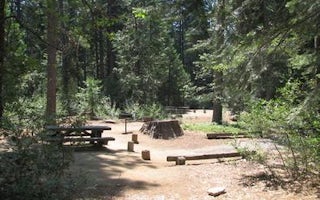
The campground offers single and double family campsites and one triple site; a few of the campsites are accessible. Picnic tables, campfire rings and grills are provided, as well as vault toilets and drinking water. Firewood is available for purchase from the host.Natural Features
Sugar Pine Reservoir covers 160 acres at an elevation of 3600 feet. The campground lies above the north shoreline, in a forest of manzanita and ponderosa pine. Summertime temperatures are warm during the day and cool at night.Nearby Attractions
Shirttail Creek Campground is a recreation site within the Sugar Pine Recreation Area which includes an additional family campground, a group campground, a boat ramp, and a day use picnic site, as well as a trail that circles the entire lake. The North Fork American Wild And Scenic River can be accessed near by. Other recreation opportunities include many hiking, equestrian, mountain biking, and OHV trails.Shirttail Creek Reviews
Have you stayed here? Be the first to leave a review!
Top Spots in or near Foresthill
Explore Sugar Pine Reservoir
Foresthill, California
4.3
Just a few miles north of Foresthill, Sugar Pine is a lesser known reservoir found in Placer County that is surprisingly unpopulated for how much the park provides. A swim suit, some friends, and some good music can be all it takes to have a good time.There is a boat-launching station that is easy to access right near the parking lot (although the lake did seem almost too small for any larger/f...
Rafting the Middle Fork American River
Foresthill, California
5.0
The Middle Fork of the American River is a fun and full day of Class III/IV water rafting. You'll experience "Tunnel Chute". An very narrow 20 foot wide chute that drops you into gold miners tunnel. Other popular drops and rapids include, Kanaka Falls, Chunder, Bus Crash, Parallel Parking, 101 Airborne and Ruck-a-Chuck. Which you will have to walk along the trail while your guide takes the raft...
Hike The Historical Stevens Trail
Colfax, California
5.0
8 mi
/ 3376 ft gain
Best known as one of the most popular hiking and biking trails to the North Fork American River, in part because of the easy access from Colfax. However, this is a remote trail, and hikers are advised to bring plenty of fluids as well as carry a whistle. The entire trail is primarily shaded, passing through oak, douglas fir, and large stands of manzanita. The wildflower displays are rarely m...
Hike to the Jumping Rock on the Bear River
Colfax, California
2 mi
/ 150 ft gain
Though lesser known than its neighbors the Yuba and the American, the Bear River still features fantastic hiking, swimming, river-raft, tubing, and rock-jumping but without the crowds.A local favorite spot, the "Jumping Rock" near the Dog Bar Crossing, provides an excellent hike with several swimming holes along the way. To get there you can either take Dog Bar Road from Grass Valley if you're ...
Take a Family Ride
Nevada City, California
4.5
Well if you start at Banner Lava Cap and Gracie Roads then you will see the canal at the top of Gracie Rd. Hop onto the berm of the canal and head north {upstream}. The trail is dirt and about 4 ft wide in the beginning and widens to 6 to 8 ft for most the way . Continue upstream on the canal and in .3 mile you will pass through a gate that has a walking access that’s too tight to get handle ba...
Photograph a Sunset on Wolf Mountain
Grass Valley, California
5.0
While all of the hiking trails to the Wolf Mountain summit cross private land, Wolf Mountain Road provides public access to several excellent viewpoints overlooking the Central Valley and the nearby ruins of old radio towers.To get there take McCourtney Road west from CA Highway 49/20 and go 3.2 miles and go left onto Wolf Mountain Road. Go 3.8 miles on Wolf Mountain Road until it dead-ends in ...
Camping and Lodging in Foresthill
Foresthill, California
Giant Gap
Overview
Giant Gap Campground is located on the north shore of Sugar Pine Reservoir, in the Tahoe National Forest. It is just 15 miles fr...
Colfax, California
Tunnel Mills Ii
Overview
Tunnel Mills Group Campground is located along the East Fork of the North Fork of the North Fork American River in the Tahoe Nat...
Placer County, California
Middle Meadows
Overview
Middle Meadows Campground offers a quiet place to camp, far from the hustle and bustle of city life. The campground is isolated ...
Emigrant Gap, California
North Fork (Ca)
Overview
North Fork Campground is located along the North Fork of the North Fork American River in the Tahoe National Forest, off of Inte...
Wentworth Springs Road
Stumpy Meadows
Overview
Stumpy Meadows, on the Stumpy Meadows Reservoir, provides an enjoyable setting in a heavy conifer forest with easy access to an ...
Wentworth Springs Road
Black Oak
Overview
Black Oak Campground is group camping destination near Stumpy Meadows Lake on the Eldorado National Forest. The forest boasts ov...
Unfortunately, we don't have up-to date pricing data for this listing, but you can check pricing through Recreation Gov.
Book NowAdd your business today to reach The Outbound's audience of adventurous travelers.
Community
© 2024 The Outbound Collective - Terms of Use - Privacy Policy


