Waddell, Arizona
Top Spots in and near Waddell
-
Phoenix, Arizona
Mojave Connector Trail #202
2.18 mi / 820 ft gainThe best starting point to access this hike is parking at the Mojave Picnic Area and heading up the Mojave Trail #200. At .4 miles, you will hit the junction and stating point for the Mojave Connector Trail. Head left at the saddle and begin a rapid ascent up switchbacks to a small flattened summ...Read more -
Phoenix, Arizona
Mojave Trail #200
4.51.88 mi / 430 ft gainThe entrance for the Piestewa Peak area is located at 2701 E. Squaw Peak Drive. The Mojave Picnic Area & Trailhead is the first parking area on the right. This is a very popular trail when the outside temps drop a bit so get there early for sunset hikes to ease parking. The trail begins on t...Read more -
Phoenix, Arizona
Ruth Hamilton Trail
3.32 mi / 981 ft gainRuth Hamilton Trail is an out-and-back trail where you may see beautiful wildflowers located near Phoenix, Arizona.Read more -
Phoenix, Arizona
Quartz Ridge Trail
4.52.29 mi / 509 ft gainQuartz Ridge in the Phoenix Mountain Preserve (also known as Trail 8A) is a great escape getaway trail that can be done as a single track or combined with many intersecting trails. It is a very popular trail for hikers, trail runners, pet walkers, sky gawkers and more! The trailhead sits in a sm...Read more -
Phoenix, Arizona
Apache Wash Loop Trail
5.79 mi / 541 ft gainThis hike begins at the Apache Wash Trailhead where you will find restrooms and a covered rest area. This loop is simple to follow and offers various shortcuts along with an access to an optional summit climb. The loop begins from the north-east end of the parking lot near the restrooms. Turn l...Read more -
Phoenix, Arizona
Hike Holbert Trail to Dobbins Lookout
4.04.1 mi / 1135 ft gainDobbins lookout is a popular high point in South Mountain Park that offers views of the entire Phoenix area. It's accessible by road or by trail with no entry fee. Consider going in the evening for the best views.If you plan to hike to the top, the shortest route is the Holbert trail. Take a l...Read more -
Phoenix, Arizona
Lost Ranch Ruins Trail to Lost Ranch Mines Trail Loop
5.04.97 mi / 1184 ft gainLost Ranch Ruins Trail to Lost Ranch Mines Trail Loop is a loop trail where you may see wildflowers located near Phoenix, Arizona.Read more -
Phoenix, Arizona
Echo Canyon Trail on Camelback Mountain
4.52.46 mi / 1214 ft gainIf you live near or around Phoenix, you know that Camelback Mountain is pretty hard to miss. Due to the mountain's height, this hike isn't exactly what you would call easy. There are two sides of the mountain you can hike, Echo Canyon and Cholla Trail. Echo Canyon is shorter, but still an extreme...Read more -
Phoenix, Arizona
Climb the Praying Monk
4.30.5 miPark at the Echo Canyon Parking Area.From the trailhead, hike up Echo trail until your reach the saddle. At the saddle, you will turn south and start taking the climbers trail to the headwall, which is just past the sign that says "caution, active bee area." Once you reach the headwall, there a...Read more -
Phoenix, Arizona
Climb the East Face of the Praying Monk
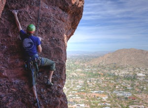
0.5 mi / 200 ft gain5.6 Sport climb, up an 80 foot face, 9 bolts to the top. This was the first outdoor climb for myself. It opened the doors to getting out of the gym and becoming a part of the local climbing community. I highly recommend it, as it is not too difficult, and can be done with a group of people. The...Read more -
Phoenix, Arizona
Hidden Valley via the Mormon Loop Trail
4.03.63 mi / 873 ft gainThis is a great spot for an afternoon hike near Phoenix. There are some beautiful rock formations, nice trails, and pretty stunning views of the city and desert beyond. It's open year round and is dog friendly so if you've got a pup, definitely bring it along. It gets super hot in the summer and ...Read more -
Phoenix, Arizona
Hidden Valley Trail Via Mormon Trail
3.63 mi / 863 ft gainHidden Valley Trail Via Mormon Trail is a loop trail that takes you by a river located near Phoenix, Arizona.Read more -
Phoenix, Arizona
Acer Summit Via Mormon Trail
2.46 mi / 758 ft gainAcer Summit Via Mormon Trail is an out-and-back trail where you may see wildflowers located near Phoenix, Arizona.Read more -
Morristown, Arizona
Experiencing Castle Hot Springs
The grounds of this location are absolutely incredible – food is amazing, and the hot springs are magical. Each hot spring boasts its own naturally occurring hybrid mix of minerals, which vary from place to place depending on the geology of the area. For the storied history of this location and ...Read more -
Morristown, Arizona
Hiking in Hells Canyon Wilderness
Spanning 9,951 acres of backcountry a few miles northwest of Lake Pleasant and about 25 miles north of Phoenix, Hells Canyon Wilderness area offers a quick way to escape into an untamed swath of desert that’s more paradise than purgatory.I have to say, this entire trail is 36.3 miles (and is tec...Read more -
Paradise Valley, Arizona
Camelback Mountain via Cholla Trail
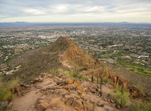
4.52.68 mi / 1158 ft gainThis challenging hike up the east side of Camelback Mountain has beautiful views of Phoenix and Scottsdale, and is not often crowded. You will begin on switchbacks heading up the mountain, with trail markers to guide you at first. The hike increases in difficulty about 1 mile in, when you reach ...Read more

