Oakley, California
Oakley, California offers some of the best trails and outdoor activities for those seeking scenic adventures. The Big Break Regional Shoreline is a must-visit, featuring a trail that winds along the San Joaquin River, providing stunning views of Mount Diablo and the river's diverse birdlife. The trail's difficulty is moderate, making it suitable for most fitness levels. For a more challenging trek, the Marsh Creek Regional Trail offers a mix of flat stretches and gentle inclines, taking hikers past rolling hills, vineyards, and the sparkling Marsh Creek. In addition to hiking, Oakley boasts top attractions like the Antioch Dunes National Wildlife Refuge, home to rare plants and butterflies. For water-based activities, the Delta provides opportunities for fishing and boating. These are just a few examples of the outdoor adventures awaiting you in and near Oakley, California.
Top Spots in and near Oakley
-
Antioch, California
Hike the Old Homestead Loop
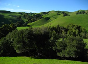
5.06.5 miThis is a fun day hike that takes you through the beautiful hills of the Black Diamond Mines Regional Preserve and a bit of the Contra Loma Recreational Area as well. You can hike here year round, but I suggest going in the spring time when the hills are covered in soft, green grass and the wild ...Read more -
Clayton, California
Hike the Waterfalls of Mount Diablo Loop Trail
5.06 mi / 1627 ft gainWinter and spring rains create scenic waterfalls in this hike at Mount Diablo, the East Bay's signature peak. Be careful hiking immediately post-rain, watch for slippery sections of mud. The trail is moderately difficult and is used by hikers, walking groups, trail runners, and for nature trips. ...Read more -
Livermore, California
Condor, Volvan, Stone Corral, Coyote Loop
4.54.38 mi / 620 ft gainThis regional preserve is perfect for day hikes. There are also designated campsites and even a backpack campsite. Horses and dogs are welcome in the preserve. There are many different clearly marked trails that one can choose from. A good 4.5 mile loop is to start at the Park Residence entrance...Read more -
Clayton, California
Hike Mt. Diablo
4.413 mi / 3323 ft gainMt. Diablo has some of the most expansive views in California, despite it's relatively low peak elevation. It played a large role in the surveying the Bay Area during its early discovery. Getting There: To get to the staging area, take Interstate 80 to I-680 to Highway 4. Exit at Railroad Bouleva...Read more -
Walnut Creek, California
Juniper to the Summit Loop Trail and Meridian Ridge
6.56 mi / 2037 ft gainJuniper to the Summit Loop Trail and Meridian Ridge is a loop trail that is strenuous located near Diablo, California.Read more -
Walnut Creek, California
Camp at Juniper Campground in Mount Diablo SP
Mount Diablo's summit in Mount Diablo State Park rises to 3,848ft, with Juniper Campground in Mount Diablo SP is at approximately 3,000ft in elevation. Juniper Campground overlooks the valley below and some of the San Francisco Bay. Reservations for Juniper Campground can be made at Reserveamer...Read more -
Danville, California
Hike in Mount Diablo's Madrone Canyon
2.8 mi / 550 ft gainThis hike starts at the Rock City area of Mount Diablo State Park. Begin at the Madrone Canyon Trail, hiking southeast towards the Devils Slide trail. Along this section of the hike, the trail dips into a wooded canyon and follows the path of a small creek. To best experience the beauty of the cr...Read more -
Danville, California
Summit Mount Diablo via Rock City Trail
5.07.8 mi / 2299 ft gainAlthough steep in sections, this trail is a wonderful workout and hikers are more than rewarded for their efforts. The Rock City Trail is a direct route to the summit of Mount Diablo, and the park is an ecological treasure dear to the hearts of Bay Area residents. The best views are on clear days...Read more -
Walnut Creek, California
Southern Lime Ridge Loop
4.05.57 mi / 1089 ft gainThe Southern Lime Ridge Loop is a trail system located near Walnut Creek, CA. There is a parking lot at the trailhead located across the street from the Boundary Oak Golf Course. The trail is fairly exposed with limited shade, so bring appropriate sun protection especially on the warmer days. D...Read more -
Walnut Creek, California
Castle Rock Trail
5.06.06 mi / 971 ft gainLocated near Walnut Creek, the trail is easily accessible from anywhere in the Bay Area. The trail is kept open year-round, and happens to be part of the American Discovery Trail and the Coast to Crest trail. If you are not done hiking, connecting trails allow you to summit Mt. Diablo. This tra...Read more -
Walnut Creek, California
Run the Mt. Diablo Foothill Loop
5.06.2 mi / 875 ft gainContinue by car down Castle Rock Road until it dead ends at the beginning of the trail. Parking is usually easy to find. If full, there is another overflow lot about 500 ft back the way you came in.You'll walk a good half mile down the trail before getting the main gate. As you're walking, you'll...Read more -
Walnut Creek, California
Sugarloaf Open Space Loop
1.91 mi / 243 ft gainSugarloaf Open Space Loop is an almost 2-mile loop for hiking, running and walking. This trail is relatively easy and takes under one hour to hike. This loop is dog friendly.Read more -
Lafayette, California
Briones Park's Lafayette Ridge
4.35.31 mi / 981 ft gainThis is a nice and casual hike through the meadows and rolling hills, dotted with cows and hawks and sometimes goats or foxes. As you head up Lafayette Ridge, you'll be rewarded with the beautiful vista spanning from the Oakland Hills to sparkling Lafayette Reservoir. The hike is mostly through ...Read more -
Moraga, California
Bollinger Creek Loop Trail
1.43 mi / 213 ft gainLas Trampas Regional Wilderness offers an extensive trail system for hikers, horseback riders and mountain bikers. The trail is open year round and dogs are allowed. The Las Trampas and Bollinger faults spread apart to reveal a wonderful wilderness area with ancient remnants of beaches. The entir...Read more -
Martinez, California
Muir Farm And Mount Wanda: John Muir Nature Trail
2.59 mi / 512 ft gainMuir Farm And Mount Wanda: John Muir Nature Trail is a loop trail located near Martinez, California.Read more -
Galt, California
Hike the Cosumnes River Walk Trail
3.1 mi / 16 ft gainThis trail is a short, easy, accessible and beautiful trail for a nice afternoon walk (or photoshoot). I recommend the River Walk Trail (~3 miles). It is flat and easy to walk. There are multiple loops so you can turn back at any time. There are small bridges, access to the water, meadows, e...Read more
Top Activities
Camping and Lodging in Oakley
Coyote Point
Oak Shores Day Use Area (Ca)

