Brighton, Utah
Top Spots in and near Brighton
-
Cottonwood Heights, Utah
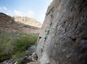
Rock Climbing at Dogwood
4.4If you can avoid the crowds, Dogwood is an easy crag to get to with a lot of 5.fun climbs and a legendary 5.13a sport climb. From the mouth of Big Cottonwood Canyon, the Dogwood picnic area is 1.1 miles up the canyon. Park on the street to avoid having to pay $8 and walk into the picnic area. Fol...Read more -
Cottonwood Heights, Utah
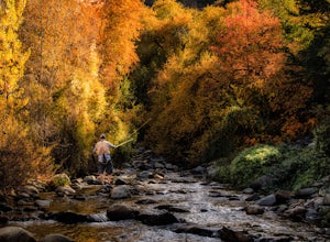
Fishing Big Cottonwood Creek
4.0Big Cottonwood Creek is a fun little creek that is often overlooked by the more popular fly-fishing waters of the Provo, Weber, and the Green Rivers of Utah. The fish aren't as big, but make up for it by being less selective with flies and a willingness to go after dry flies any time of the year....Read more -
Cottonwood Heights, Utah
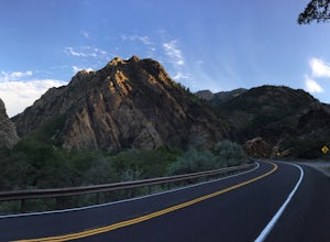
Cycle Big Cottonwood Canyon
5.0Big Cottonwood Canyon (BCC) is one of the longest rideable canyons in the Salt Lake City area, taking you from the base of the canyon to Brighton Ski Resort. Riders have the option to ride any length of the canyon, all of which will be visually rewarding.There are 3 relatively steep sections in B...Read more -
Provo, Utah
Hike the Pine Hollow Trail
4.04.4 mi / 1100 ft gainThe trailhead (Forest Trail 047 - Pine Hollow Trail) starts across the street from a turnout about .5 miles above Mutual Dell in American Fork Canyon. This highly trafficked trail is used for just about every activity you can think of, meaning that you can even snowshoe this in the winter. It's a...Read more -
Salt Lake City, Utah
Hike Neff's Canyon
4.3From the parking lot, you will follow a 4-wheel drive track that runs straight up to the beginning of the different trailheads. You can also take an actual trail up to that same spot, situated below the 4-wheel gravel track on the righthand side.There are a few different trails that merge togethe...Read more -
Holladay, Utah
Hike Heughs Canyon (Olympus Waterfall)
4.52 mi / 1000 ft gainHeughs Canyon starts right on the edge of Salt Lake City, but within minutes, you’re in a shady forest next to a gurgling stream. This is the prefect after-work hike that can be enjoyed year-round. Two miles round-trip and just over 1,000 feet, the path takes you to a beautiful waterfall that flo...Read more -
Summit County, Utah
Mountain Bike the Genwild/Jeremy Ranch Trails
6 mi / 700 ft gainThere are several places to access the trail system and several good places to park on both the Jeremy Ranch side and the Glenwild side. One of my favorite options is to park at the end of Jeremy Road and then take the 24-7 trail into the action. This is also a good way to access the Flying Dog t...Read more -
Salt Lake City, Utah
Hike Mt. Aire
4.54 mi / 2000 ft gainMount Aire, standing around 8600 ft, certainly isn't the most inspiring peak in or around Salt Lake City, but to me it serves as a quick summit to catch the sunset when I'm short on time.Getting There:Start by heading up Mill Creek Canyon Rd. After passing the ranger booth, drive about 5.5 miles ...Read more -
Sandy, Utah
Bell Canyon's Waterfall
4.64.64 mi / 1549 ft gainIf you keep a steady pace, the hike takes about an hour each way, so allow time when trying to catch the sunset. The hike is pretty easy until right before you reach the falls, where there is a big, steep hill you have to climb. From the parking lot/trailhead, head up the path and head left when...Read more -
Salt Lake City, Utah
Climb West Slabs of Mount Olympus
5.0Park at the top of Thousand Oaks Drive, and make your way to the dirt path heading east. It will be a well maintained, well-covered single dirt track which takes you to the base of a really impressive couloir. Follow the trail until you reach the couloir / rocky gully. You will then see the West ...Read more -
Sandy, Utah
Upper Bell Canyon Reservoir via Bell Canyon Trail
4.39.12 mi / 4285 ft gainThis is one of my favorite spots in the state of Utah! It is completely secluded high up on the Wasatch front. You can hike here for a nice relaxing day, an overnight camping trip, or do a little fly fishing and hook some fun little brooke and cutthroat trout. The Bell Canyon trail is one of the...Read more -
Sandy, Utah
South Thunder Mountain via Bell Canyon
11.78 mi / 5968 ft gainStarting at the Bell's Canyon trailhead, the trail follows a river for most of the way, passing two reservoirs and two waterfalls. This trail is intermediate, depending on your destination. The first and most commonly visited section of the trail is the first reservoir. An easy hike of less than ...Read more -
Holladay, Utah
Winter Hike to Mt. Olympus
5.07 mi / 4200 ft gainApproach: You can access the well traveled Mount Olympus Trail the same as you would any other season. Park in the trailhead lot or along Wasatch Blvd. The trail starts on the south side of the parking lot.Route Description: Even in the winter the Mount Olympus trail should be pretty straightforw...Read more -
Provo, Utah
Camp at Timpooneke Campground
5.0The Timpooneke Campground sits at 7,400 ft. elevation with views of Mount Timpanogos and campsites surrounded by beautiful aspen, fir and spruce trees. The leaves in the fall put on a show you will not want to miss. Within the campground there are 9 equestrian sites, 1 large group site and 20 sta...Read more -
Alpine, Utah
Horsetail Falls - Dry Canyon
5.04.01 mi / 1808 ft gainHorsetail Falls is a somewhat short hike located near Alpine, UT. The hike has good elevation gain and will make you work a bit to get there. The reward is worth the effort as you arrive at the falls and take a great view while being refreshed in the mist of the falls. The trail is straightforwar...Read more -
Holladay, Utah
Mt. Olympus Trail
4.76.46 mi / 4124 ft gainThe trail begins right on Wasatch Blvd. and after the first 0.5 miles you're into the Superior Wilderness. This is a very strenuous hike and you will be gaining elevation the whole way from the parking lot (4830 ft) to the summit (9026 ft). About .2 mile from the summit you will reach a saddle....Read more

